Departing from Teramo go toward Montorio al Vomano crossing the S.S.80 for 800 ms in slope toward Frondarola. Once you reach Rocciano crossroad the road begins to go down toward a fountain. After a brief tear in slope of 500 ms you reach Collevecchio crossroad, that leads you in the main route and then you go down toward Montorio al Vomano, considered a real "showcase" for the cultural and landscape beauties and from years stung of departure of the cycling competition "Giro del Gran Sasso."
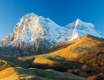
Continuing in slope toward San Giorgio, you can admire a splendid panorama of Gran Sasso.
(San Giorgio can also be reached through the tratturis that climb from Frondarola or from Faceto).
Go on a brief line in slope toward Rocca Roseto, a fortification used as point of watch of a strategic street of passage between Roma and Adriatic.
After few meters you arrive in Piano Roseto. In these places, overhung by Monti della Laga chain you can see sheep and goats to the pasture and if you are fortunate, in the clear days, you can also see up to the Adriatic Sea.
From here go toward Cortino crossing a road that introduces a run where still today you can see “Formazione della Laga”, that are geologic layers of marl and sandstone. Going on, and overcoming Fonte Palumbo, you arrive in Pagliaroli where, the excavations effected in 1997 near the church of San Salvatore, have brought to light the rests of a temple of great dimensions.
Here you can stop by the fountain or to the cafe and then to go back to Teramo, crossing the fractions of Cunetta coasting along Valle San Giovanni, Travezzano and Villa Tordinia.
The main cities are: Teramo, Frondarola, Montorio al Vomano, Villa Vallucci, Schiaviano, San Giorgio, Piano Roseto, Cortino, Comignano, Fonte Palumbo, Pagliaroli, Cunetta, bivio Valle San Giovanni, Travazzano, Villa Tordinia, Teramo.
*we always recommend you the use of a helmet and to bring proper attire for the season, a kit for perforations and for first aid.*
Technical data:
- Difficulty: High
- Maximun height: 1250 m. Piano Roseto
- Development: 65900 m.
- Duration: 04:00:00
- Suitable for cycling: Good
- Type of fund: Asfalto in discrete condizioni
- Altimetry
- Trend : Climb - Drop : 1244 m.
- Trend : Climb - Drop : 1244 m.
 en
en 


